The marine environment is highly dynamic, driven by forces such as wind and currents, among many others. A pragmatic way of envisioning the ocean is by seeing it as a sum of forces, though there are many forces and studying each one is a complex task that requires different approaches like in situ research or numerical modelling. Understanding interactions between the atmosphere and the ocean is instrumental to identify which processes are occurring at regional and local scale. Biologically, these insights offer answers regarding connectivity between sites.
At a local scale, circulation can be driven by winds. In the Caribbean Sea, the Northern Trade winds are a major force in the surface, as well as the Caribbean Low Level Jet that exerts a constant flux of wind to the west throughout the year. Wind interaction at the surface creates turbulence, which may mix the water column, creating a deeper mixed-layer. This means that upper and lower layers are similar in terms of physicochemical parameters: temperature and salinity are more uniform than in shallower mixed-layers.

In the Atlantic Ocean, the Caribbean Sea is the largest marginal sea, bigger than the Gulf of Mexico in surface area and the Mediterranean Sea in volume. Its basin can be divided into five principal subbasins which, ordered from east to northwest, are: the Grenada, the Venezuelan, the Colombian, the Cayman, and the Yucatan Basins.
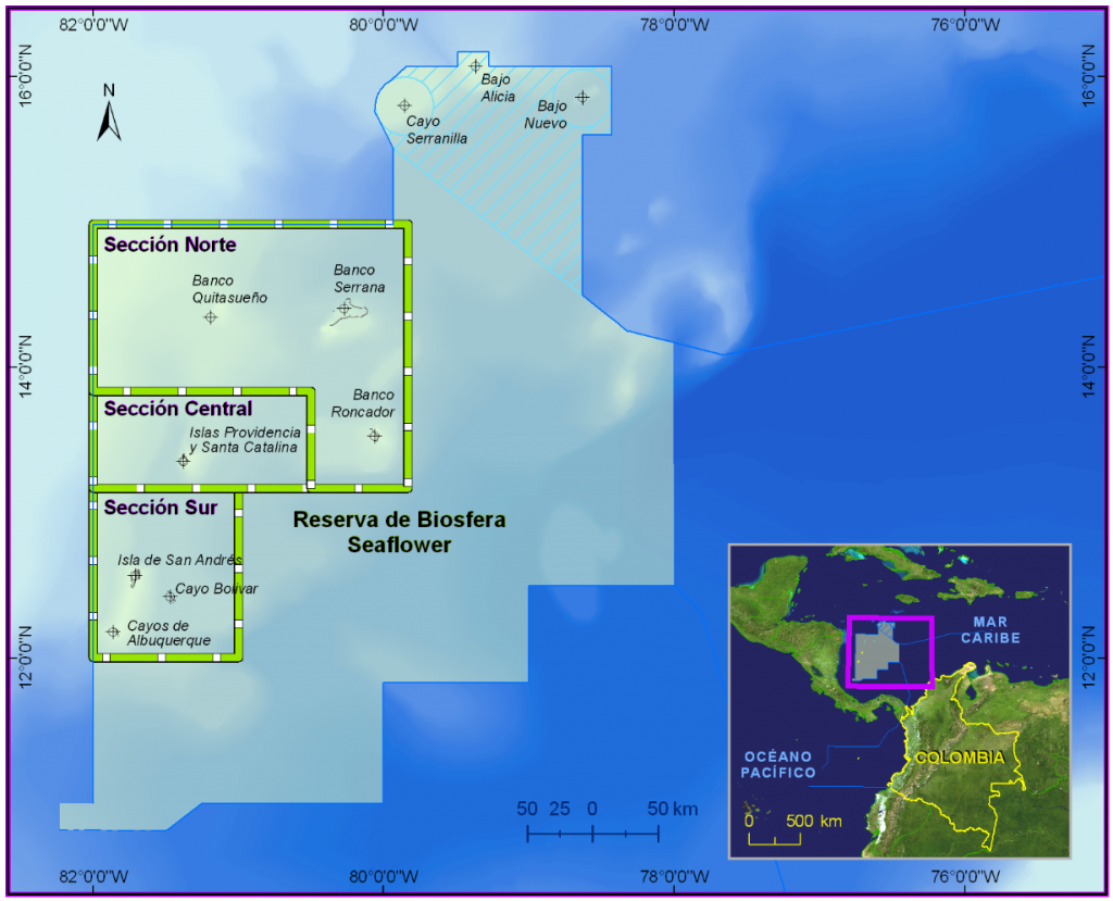
The Archipelago of San Andres, Providencia, and Santa Catalina (ASAPSC) is located within the Colombian basin. It consists of oceanic islands and many atolls and banks on a volcanic basement, aligned along the Lower Nicaraguan Rise in the Southwestern Caribbean. Its origin is associated with the tectonic-volcanic activity that formed the Central American isthmus, in the middle Miocene. San Andres and Providencia (with Santa Catalina) islands, along with the Quitasueño, Serrana, Roncador, Albuquerque and Bolivar atolls and the Serranilla, Bajo Nuevo and Bajo Alicia banks comprise the Seaflower Biosphere Reserve (SFBR).

Circulation in SFBR is determined by two major drivers: the Caribbean Current and the Panama-Colombia gyre. The Caribbean Current is a zonal current that enters from the Lesser Antilles and flows from east to west. Because of geomorphological elements in the Nicaraguan Rise such as cays and islands, it divides into two sections. A portion of the current goes towards the Cayman Sea, while the other goes south of the SFBR and forms the Panama-Colombia gyre, a semi-permanent gyre with cyclonic rotation, which means that it rotates with Earth rotation, counterclockwise in Northern Hemisphere and clockwise in the Southern Hemisphere. Other drivers of circulation are mesoscale and submesoscale eddies that may occur seasonally. Surface currents are affected by a continuous presence of eddies travelling with the Caribbean Current, rotating in both directions.
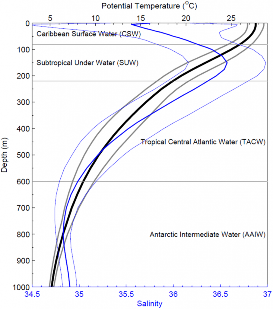
In ASAPSC, the water column is characterized by four water masses. From the surface down to 50-75 m, the Caribbean Surface Water with low salinity is present. Deeper, a second water mass between 150-200 m consists of the Subtropical Subsurface Water, with the peak salinity in the entire water column. The third water mass, the Subantarctic Intermediate Water, is present between 600-900m and has the lowest values of salinity. The last and deepest water mass is the North Atlantic Deep Water. Each of these water masses has a signature, a value of temperature and salinity that allows its identification when studying the water columns. Its implications are the understanding of currents below the surface, which leads to characterization of water masses in basins.

Data of interest:
Based in numerical simulations, researchers Andrade et al. (2003) suggested that there is evidence of a counter to the Caribbean and eastward subsurface current. It flows along the southern Caribbean, from Colombia to Venezuela, exiting the system through the Grenada Channel.
In coral reef formation within the SFBR, an interaction of wave exposure by wind action and the oceanic location generates a turbulence that controls the distribution of organisms in the reefs.
Drifters may be used to study circulation and currents in the ocean. These are released into the ocean and monitored. Its movement is determined by surface currents, so they work as a direct proxy to understand circulation.
References:
Beier, E., Bernal, G., Ruiz-Ochoa, M., & Barton, E. D. (2017). Freshwater exchanges and surface salinity in the Colombian basin, Caribbean Sea. PLoS ONE, 12(8), 1–19. https://doi.org/10.1371/journal.pone.0182116
Centurioni, L. R., & Niiler, P. P. (2003). On the surface currents of the Caribbean Sea. Geophysical Research Letters, 30(6), 10–13. https://doi.org/10.1029/2002GL016231
Díaz, J., & García Llano, C. (2010). Moluscos del Mioceno y del Pleistoceno de la isla de San Andrés (Mar Caribe, Colombia) y consideraciones paleobiogeográficas. Revista de La Academia Colombiana de Ciencias Exactas, Físicas y Naturales, 34(130), 105–116.
Gallegos, A. (1996). Descriptive physical oceanography of the Caribbean Sea. In G. A. Maul (Ed.), Small islands: marine science and sustainable development (Vol. 51, pp. 36–55). https://doi.org/10.1029/CE051p0036
Idárraga-García, J., & León, H. (2019). Unraveling the underwater morphological features of Roncador Bank, archipelago of San Andres, Providencia and Santa Catalina (Colombian Caribbean). Frontiers in Marine Science, 6(FEB), 1–15. https://doi.org/10.3389/fmars.2019.00077
Lopera, L., Cardona, Y., & Zapata-Ramírez, P. A. (2020). Circulation in the Seaflower Reserve and Its Potential Impact on Biological Connectivity. Frontiers in Marine Science, 7(June), 1–17. https://doi.org/10.3389/fmars.2020.00385
Sánchez, J. A., Pizarro, V., Acosta-de-Sánchez, A. R., Castillo, P. A., Herron, P., Martínez, J. C., Montoya, P., & Orozco, C. (2005). Evaluating coral reef benthic communities in remote Caribbean Atolls (Quitasueño, Serrana, and Roncador Banks) to recommend marine-protected areas for the seaflower biosphere reserve. Atoll Research Bulletin, 531–542, 1–65. https://doi.org/10.5479/si.00775630.531.1
Torres-Parra, R. R., Sánchez-Reyes, D. M., & Moreno-Calderón, M. Y. (2017). Variación estacional del nivel del mar en el Archipiélago de San Andrés, Providencia y Santa Catalina, Mar Caribe. Revista de Biologia Marina y Oceanografia, 52(2), 343–352. https://doi.org/10.4067/S0718-19572017000200013
Vargas-Cuervo, G. (2004). Geología y Aspectos Geográficos de la Isla de San Andrés, Colombia. Geología Colombiana, 29, 73–89.


